The MT WHITNEY hike is on every hiker's bucket list. At 14,503 feet, this is the highest point in the contiguous united states and is one of those high peaks that you hike to without mountaineering skills. But before attempting this hike, I would suggest to do some training hikes above 10,000 feet. As a southern Californians, we hiked the famous "Six Pack of Peaks", Mt Wilson, Cucamonga Peak, Mt Baldy, Mt San Bernardino, Mt San Jacinto and San Gorgonio.
Trail head address:
Mt. Whitney Trailhead, Whitney Portal, CA, 93545, USA
You have to do a lots of preparation to hike this mountain. You can't just go to the trail head and start climbing.
- To hike this mountain, you need to get the permit. Getting the permit is tough and require a lot of luck as it involves the lottery, because they give permits only to 100 groups per day. Each group can have a maximum of 12 persons. Before applying for the permit, you have to chose whether you are going to take the Mount Whitney trail or some other trails which requires a mountaineering skills. The most popular route is the Mt Whitney trail from the Whitney Portal which is around 10-12 miles from the town Lone Pine where we stayed the day before the hike and after the hike. This trail is a 22 miles round trip day hike. Normally people will do this hike as a backpacking one, but getting the permit is difficult as they allow only 60 compared to a day hike permit of 100.
- Then you have to choose your accommodation option. Either you can stay in Lone Pine and drive to Whitney Portal for your hike or you can camp close to Whitney portal. People who hike this mountain as a day hike wake up at 2:30 AM and drive to Whitney portal and start the hike no later than 3:30AM. We started from the trail head at 3AM.
- Because this peak is at 14,500 feet, you need to acclimatize at least 24 hours to get used to the height. This will reduce your altitude sickness. The recommended option would be doing a small hike one day before the actual hike. We hiked till the lone pine lake which is around 3 miles from the portal. But going there and staying there for couple of hours will do the trick.
The Mount Whitney view from Lone Pine downtown.
We got our Permit, WAG bag and all other necessary information here at the Visitor center in Lone Pine. They have some good souvenirs too.
It was August 27, 2016 at 3'o clock. We were at the Mt Whitney Trail starting our one of the biggest dream - Hiking the Mt Whitney in 'ONE' day.
Started hiking early morning at 3'o clock. Mountain on both your sides, sound of waterfalls and walking with headlamp - What an awesome experience. At around 3 miles, we reached the Lone Pine Lake and after the lone pine lake, we officially reached the Mt Whitney Zone. From here on wards, we need a permit to hike further. That's why they recommend hiking till Lone pine lake the day before the hike to acclimatize yourself.
After few switchbacks, we descended to a beautiful meadow that stretches for at least half a mile. At around Sunrise, we crossed the Outpost Camp area. Normally people who does backpacking will camp here (At around 4.5 miles).
After couple of more switchbacks you find yourself at the beautiful Mirror Lake. The following picture shows the Mirror lake - This is mirror lake because it mirrors the mountains back of it. This lake is smaller than other lakes on the path, Lone Pine Lake and Consultation Lake.
A Selfie Time :)
We see the sunrise at 11,000 feet. It was awesome to see the sunrise from that height. The better part, we were at around 1/3rd of the total distance when the sun came. That gave us a confidence that we can reach the summit around noon. But that was not the case :(
A Panoramic view from top of the Mirror Lake
We saw lots of people even before us which means they might have started at least before 3'o clock.
At around 4.5 mile we had our breakfast.
One of my favorite place on the whole hike is Trail Side Meadow - It is a snow fed waterfall that slowly flows down the rock fall into the line of meadows that house beautiful purple flowers. It was like a heaven in front of us.
After a mile, we reached this beautiful Consultation Lake at around 12,00 feet. It was beautiful and had snow all around it that melts into it. The trail never goes closer to this lake as in Lone Pine lake or Mirror lake but you can see it from here as well as from the famous 99 switchbacks.
After half an hour, we reached the Trail Camp - The home to the most of the overnight hikers. This little camp area has lots of flat surfaces to put your tent in.
There is also a nice lake here to help to filter water thus making this place is the great one for the over night stay.
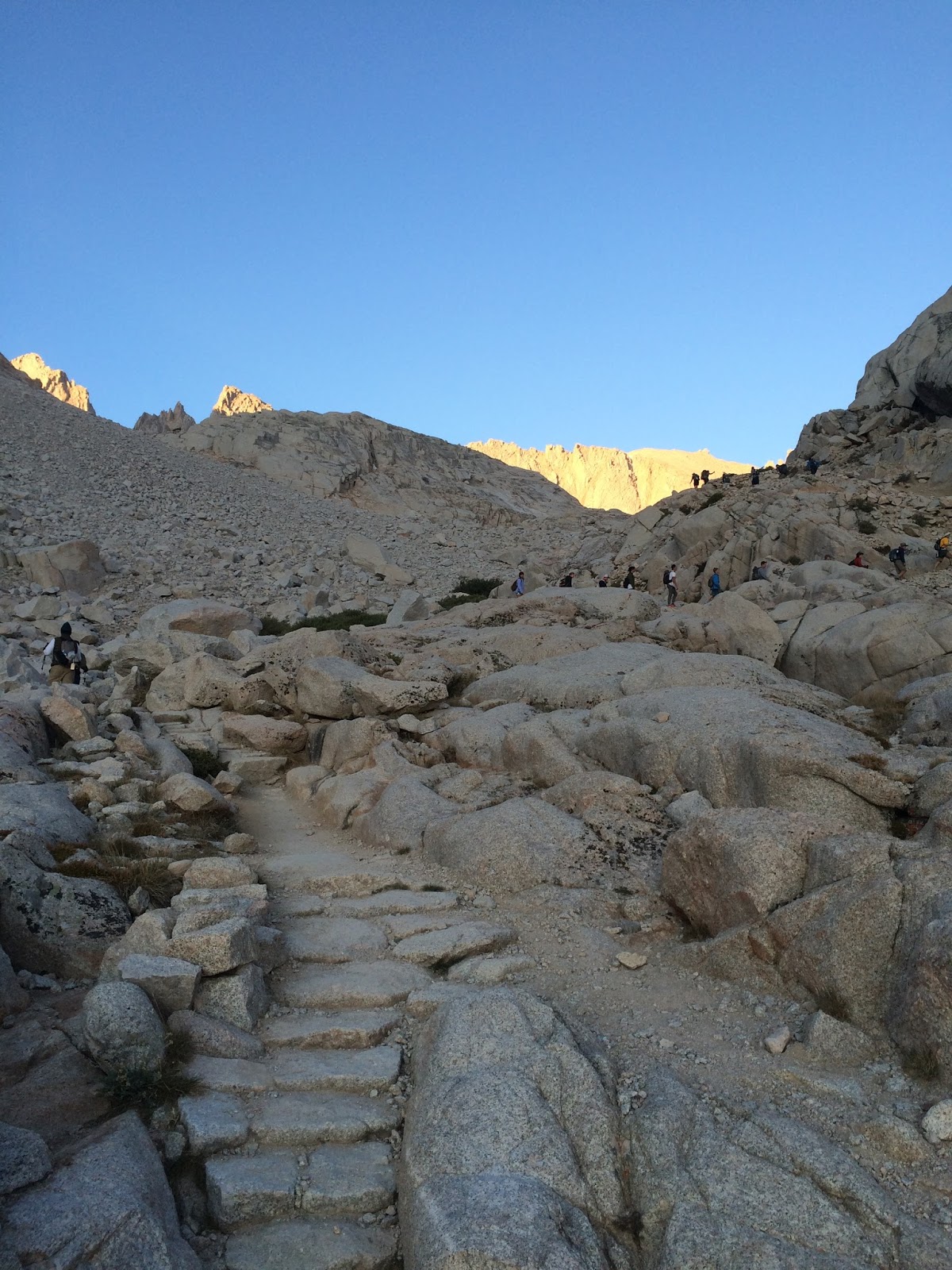
If you are researching the Mt Whitney hike, then I have no doubt that you might have heard about the famous "99 Switchbacks" - This is the second hardest part of the hike.
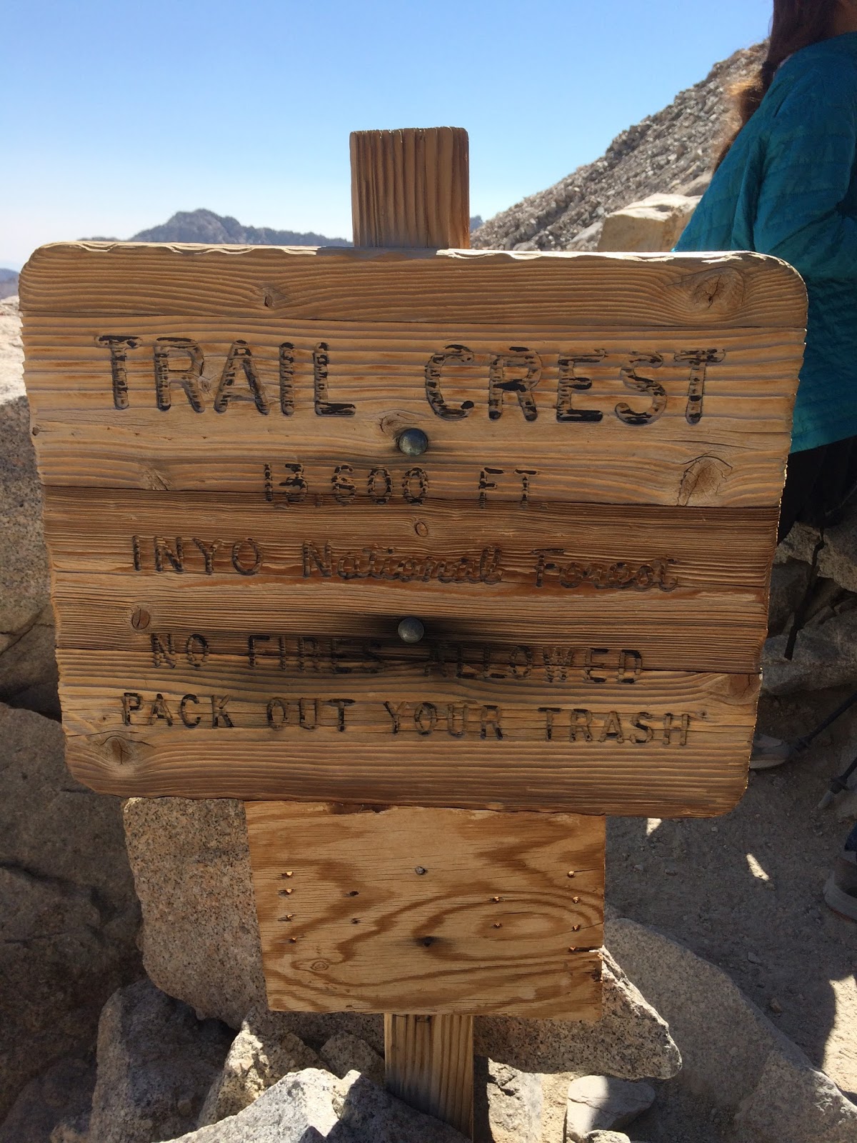
This area has legitimately 99 different switchbacks that rises over 1600 feet (From 12,000 feet to 13,600 feet) to the trail crest above.
They seem endless going up and coming down.
At one place in the 99 Switchbacks, they have a small 50 feet section called 'The Cables'. This section gets its name from the cables that line the trail to keep the hikers from falling off the steep face to the right.
Once we crossed the 99 Switchbacks, we reached the place called 'Trail Crest' which is at 13,600 feet. Initially we thought once we crossed the 99 Switchbacks, then it is like a cakewalk. But that was not the case. The worst part yet to come in the last 1.9 miles from here.
This small area has a great view of both the Whitney trail that you came up on the right hand side and the amazing Sequoia National Park on the other side.
Once we saw this board, we felt that we almost reached the summit as it was less than 2 miles. But this was the place we thought of going back as the last 1.9 miles looked like 9.1 miles :) From here, it’s only 1.9 miles and 845 feet of elevation gain to the summit – although it may be one of the most draining 2 miles we've ever hiked.
Here’s the junction with the JMT up close. Hike to the right toward Whitney. Through-hikers sometimes leave their backpacks here to summit. If you’re a day hiker or left your pack at Trail Camp, I don’t recommend leaving your gear here. The summit is probably where you need your gear the most. This is also a good point to do a gut check on AMS. If you’re feeling bad, rest and/or turn around.
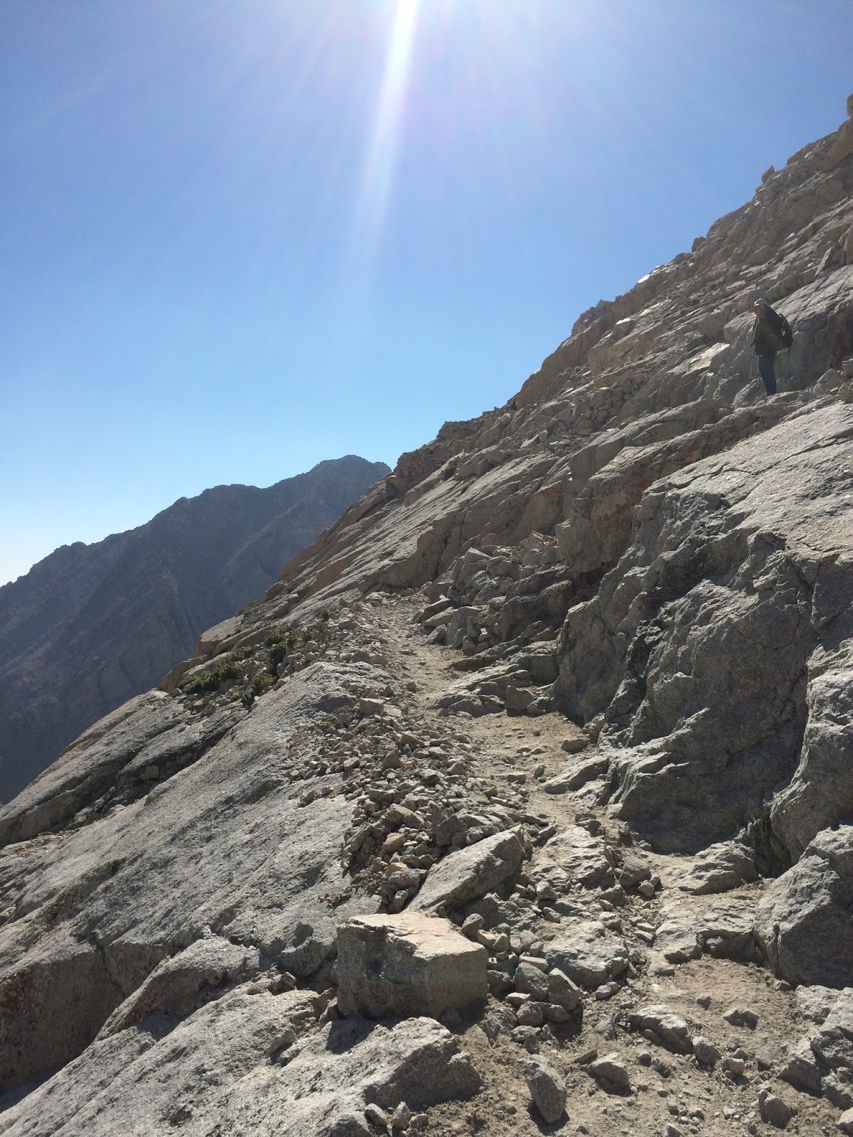
You have to keep walking walking walking etc. There were still switchbacks that you had to cross. You had to climb the rocks. From the trail crest, the summit is only 1.9 miles but we took almost 2 hours just to cross this 1.9 mile.
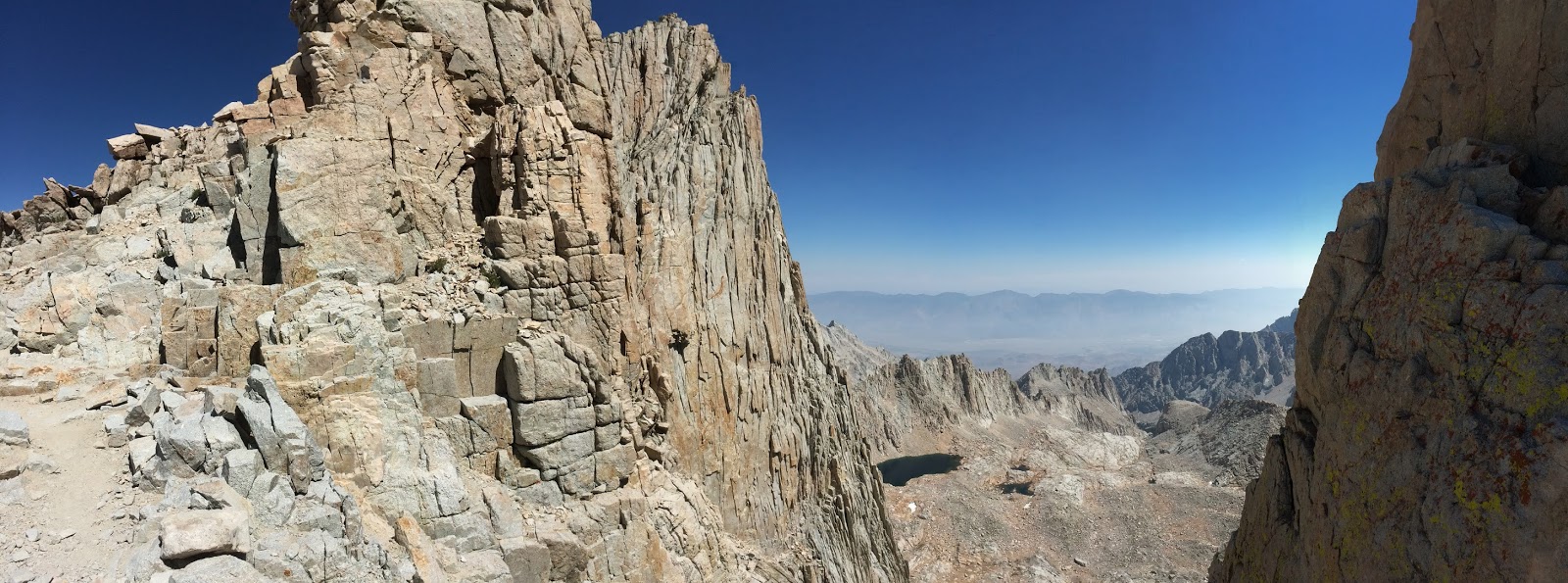
Here is the view of Needles looking backward from the trail. These are the jagged peaks. Here, the trail is entirely on angular slabs of granite. It might not be great on your knees or feet, but for the most part the trail is extremely stable – even though it doesn’t look like it.
This is called a Whitney Windows section. You can see a 1500 feet deep between two peaks before going to Mt Whitney.
It’s tough to get the sense of vertical drop into pictures of the windows, but it’s pretty much just straight down right below us there. After the windows, the trail ascends gradually through the rock field.
Take a deep breath and keep hiking. Ohhhhhhh. Finally we saw the Emergency Hut on top of Mt Whitney. The first thing you will notice when nearing the summit is this Emergency hut. This hut was built in the year 1909.
The last stretch to Mt Whitney summit doesn't have a lots of climbing, but will feel tough because of the altitude.
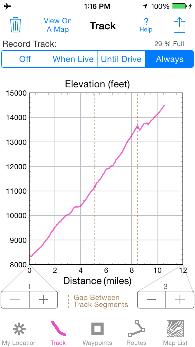
My App, 'IHikeGPS' shows that we started at around 8,300 feet and reached the summit (14,503 feet) by climbing close to 11 miles.
That was our Hiking Permit. August 27 2016 - One of the unforgettable day in our life.
We congratulated ourselves – We were the tallest thing in the continental United States!. We officially made it to the top of Mt Whitney - The tallest mountain in the whole lower 48 states of the USA. The view was stunning. Just relax and enjoy. You can see almost all the mountains till 170 miles from here. We can even see the San Gorgonio (The tallest mountain in Southern California at a height of 11,500 feet).
The 360' view was amazing. In addition to Kings Canyon and Sequoia, you will be able to look east to Lone Pine, White Mountains and Death Valley.
We made sure that we signed our names on the Guest Book. Number 10 and 12 summarizes our thoughts...)
We reached the Mt Whitney trail at 10:19 PM after almost 20 hours. My watch shows that I have taken 30,838 steps to complete this hike. That was a huge number considering that we didn't just walk, we hiked. No matter how fit you are or how little AMS you suffered, Mt Whitney hike is going to be tough in whatever way you slice it.
23.19 miles, 17 hours 33 minutes and 25 seconds, 6700 Calories. That was a HUGE number, if you ask any hiker.
I got this T-shirt from Whitney Portal Store the next day after the hike: